Lake FUBAR Rocks to Mexican Tune! Saturday Hat Dance All Over the World!

A 6.6M earthquake off Mexico’s Pacific side SHOOK UP Lake Fubar!

USGS quake report  LA-18
LA18_MexQuake2016THEN . . . 

Something big happened around 9 p.m. CST —

and it doesn’t match any quakes on the USGS list.

LA18_MexQuake2016b

[ CLICK ON IMAGE FOR FULL SIZE ]

heli_button


SATURDAY UPDATE  (1-23)

Walter noticed ALL the helicorders all over (not just Louisiana) are goin’ nuts.

THEY ARE!
Check this worldwide helicorder map and check ANY location now and compare to Friday or Thursday. You will see the familiar Mexico quake on the Americas’ helis. And then everything goes batsh-t crazy today!

We did some screen grabs from the world monitoring site.

crazyquakes

[CLICK ON IMAGE FOR FULL SIZE]

WWhelis12316

WWhelis12316b

We added 2 new links to the Seismic Monitoring section on the right sidebar (this map plus the frac quake page from VA Tech).
rightside

SUNDAY:  7.1 quake up in Alaska. We don’t know what this means for Lake FUBAR.

USGS Report –  see also update about that area on the Yellowstone blog.


Some Drinking Water News –

It’s not just Flint that’s poisoned mentions New Orleans

The drinking water in St. Joseph (Tensas Parish) is in very bad shape. There is awful brown water coming out of the taps. See photos here: http://www.saintalbansepiscopal.org/2016/01/st-joseph-water.html

The city was appropriated $6m to fix its water system. But the town failed to provide an audit to the state government, which has blocked the funding from reaching the town.  http://www.hannapub.com/franklinsun/st-joseph-fails-to-hand-over-financials/article_02eb5d80-b5cb-11e3-862c-001a4bcf6878.html  This failure of leadership is hurting the community. The people need strong leadership to get the funding to fix the problem. Further, the city needs state and federal intervention.

Please sign the petition to get federal intervention here, and please forward this along to your members: http://petitions.whitehouse.gov/petition/clean-drinking-water-st-joseph-louisiana

Thurs. News + Big Alaska Quake + Victory for Save Lake Peigneur

Heli_ANI
fluid

Crazy amounts of seismic activity and fluid movement continue at Lake FUBAR. Officials still mum.

Here is LA12 this morning:

LA12_Sept25_2014

CLICK IMAGE FOR FULL SIZE

heli_button

stability

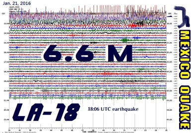
The USGS is hiding the big Argentina quake yesterday. Now there is a big 6.2 quake up in Alaska. It is today, but the time in UTC seems all wrong. It is not yet 5 p.m. CST.

Sinkholes Open, Swallow Fortunes in Costly Game of Subterranean Roulette

NOLA Defender Russel Honoré Goes One on One With Al Gore < has video, Bayou Corne mentioned at 7 min. mark

LINK –  http://youtu.be/3YZAagP0PAE

Wed. – Save Lake Peigneur wins its lawsuit  smile2  smile2  smile2

NEW IBERIA – Judge Keith Comeaux of the 16th Judicial District Court based in New Iberia reversed the decision of the Louisiana Department of Natural Resources (LDNR) to issue a Coastal Use Permit to Jefferson Island Storage & Hub for its proposal to construct and operate two natural gas storage caverns in the Jefferson Island Salt Dome under Lake Peigneur.
The court agreed with the plaintiffs that the LDNR should not have issued the permit without first finding out that the project would not unreasonably endanger public safety and that the location had foundation conditions sufficiently stable to support the use.

About Lake Peigneur

Further, the court ruled that the LDNR decision violated its Constitutional duty as public trustee of the environment under Article IX, section 1 of the Louisiana Constitution because it did not do an environmental impact analysis of the potential impacts of the project. . . .

WED. & THURS. NEWS

WEDNESDAY

SF ChronicleAnswers on link between injection wells and quakes

[internet problem seems fixed for now 🙂 ]

THURSDAY

Helicorders grmubling at 5 a.m. – It isn’t workers. July 10 story (we missed) from WAFB – has video. Oh, but they went back to Code 1. Still work doesn’t usually start til about 7 or 8 a.m. at Lake FUBAR.

UPDATE: At 6:49 a.m. CST there was a giant 6.0 quake up in Alaska. It may affect helicorders. At 7:12 LA14 had major fluid movement but not all the helicorders showing that. LA12 had the same starting a few minutes earlier. But LA12 was already grumpy before the Alaska quake.

Real Coastal WarriorsFlesh-eating bacteria in the Gulf, more. BP screwed up all the lifeforms in the Gulf.

The DNR hasn’t put out a subsidence report since January(!). Did they not bother to do one or are they just keeping it secret? And the last bubble site map was from May. It shows lots of sites north of LA70. What’s a “seismic shothole”??

France weighs in on Bayou Corne disasterEnglish translation, original: Quelque chose d’énorme qu’ils ne veulent pas que vous voyez : Update sur le Sinkhole de la Louisiane

Unexplained: Temporary, Ark. helicorders are doing skiing moguls. What the heck??


thanksreaders

Weekend News – Terrible Seismos Sunday – 7.9 quake Alaska

SATURDAY

In spite of setting the helicorders to nearly unreadable micro-settings they still show larger seismic activity at Lake FUBAR.

After 2 a.m. Saturday this big burp at LA19

LA19_Jun28_2014

 SUNDAY     fluid

Very big, sustained fluid movement, shaking after midnight, after 2 a.m. and 4 a.m. Sunday morning. Also very visible on LA14 and other helicorders.

LA10-03 :

LA10June29_2014

UPDATE:

It is grumbling at 11 a.m. too.  heli_button

 Very large quakes went off below Patagonia overnight. 6.9 quake and 5.1  and another 5.1 very nearby at the same time. There was a 6.2 quake off Iwo Jima Japan too. General seismic mayhem worldwide.

Dutchsinse –  Earthquake overview + MULTIPLE seismic monitoring links for you to use (national and international)

UPDATE:

Many more giants quakes worldwide –

Another 6.2 down there below S. America

7.9 quake in Alaska

6.9 quake near New Zealand and 6.2 quake off Tonga. LA10-03 showing all the new big quakes very well on the afternoon chart.

Time zone converter     USGS quake page – LIVE info

Yellowstone  area (Utah) felt it.

NEWS

(June 24) Colorado suspends oil and gas wastewater disposal well after quake

(Reuters) – Disposal of wastewater from oil and gas drilling into a Colorado well was ordered halted this week after seismic activity was detected in the area, state regulators said on Tuesday.

The Colorado Oil and Gas Conservation Commission ordered High Sierra Water Services to stop disposing wastewater for 20 days into the well in Weld County after seismologists detected a small 2.6-magnitude temblor on Monday. That came after a 3.4-magnitude earthquake shook the area on May 31. . . .

LINK –  http://youtu.be/FdMJLtnEOUY

[ Note – when they mention a ‘sock’ they mean a storage bag like a mail pouch ]

thanksreaders

Monday News – Big Quakes Globally

There is a big 7.2 earthquake north of New Zealand, half way to Tonga. It was at 2:20 p.m. CST.

Lake FUBAR over-reacts

LA10_03_Jun23_2014

Around 8:45 p.m. something splashed at the bottom of LA10 – 03! It shows even better on LA12 monitor. Another huge SLOSH at 11 p.m..

7.9 quake Alaska

Followed by

6.9 quake nearby (Alaska)

Two 7.2 quakes near each other in Tonga area.  #1   #2

Dutchsinse sees a HAARP connection.

Texas – More than a half-dozen Union Pacific tanker cars have derailed in Central Texas and some are leaking a chemical used in natural gas processing. . . .

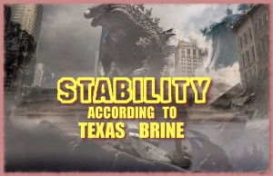
Texas Brine put out a fact-sheet. This one has a graph showing what a good job they are going with gas mitigation. They don’t mention all the earthquakes.
Yellowston Updated

 NOTE: Having great difficulty with extra slow internet Monday eve. It may be because of all these earthquakes!

Nature Runs Amok at Yellowstone < UPDATED

***  Other magma related stories here too  ***

ItemActivity after 1 p.m. at Yellowstone today.

History: “The volcanic eruptions, as well as the continuing geothermal activity, are a result of a great cove of magma located below the caldera’s surface. The magma in this cove contains gases that are kept dissolved only by the immense pressure that the magma is under. If the pressure is released to a sufficient degree by some geological shift, then some of the gases bubble out and cause the magma to expand. This can cause a runaway reaction. If the expansion results in further relief of pressure, for example, by blowing crust material off the top of the chamber, the result is a very big gas explosion.”

Yelowstone is an 8 on the  VEI Index:  “super-colossal” (if it blows).

Documentary: Yellowstone National Park & the Caldera Super Volcano

LINK –  http://youtu.be/astR0Gjy8Ps

Before It’s News – Yellowstone Magma Chamber Animals Leaving Yellowstone? What Do They Know We Don’t Know?

Mar. 30 – 4.8 earthquake rocks US Yellowstone National Park

OLD: Feb. 2 – Staggering Underground Activity At Yellowstone Lake (Volcano)

KTVU – Buffalo running from Yellowstone a feared sign of pending eruption

UPI – Yellowstone volcano: Could fleeing animals predicate eruption?

Some science people say don’t worry – Earthquake Shakes Yellowstone But No Volcano Threat Looms, Scientists Say  But evidently everybody is worrying – Animals Allegedly Fleeing Yellowstone Results In Yellowstone Volcano Search Trend. . . and those were not small quakes there this week.Yellowstone National Park rattled by largest earthquake in 34 years

Yellowstone fighting online supervolcano rumors

” . . .  Although the YouTube video says the animals are leaving, park spokesman Dan Hottle told the Jackson Hole Daily (http://bit.ly/1hcK4VV) that they are actually running toward the park’s interior and the volcano. “

Yellowstone animal exodus: Did they detect ‘something deadly’?

LINK –  http://youtu.be/cq6DK4U7Esg

LINK – http://youtu.be/pjAbRUmebyg

LINK –  http://youtu.be/uiAc4KI5iJY

Park official: Why do some animals leave the park? Winter.

Yellowstone Nat’l Park website – Volcano Questions & Answers

Montana – KPAX – Yellowstone fleeing’ bison video has Missoulians talking

Yellowstone Volcano Eruption: Scientists Proven Wrong About Supervolcano as Elk Flee Park?

Yellowstone ‘fleeing bison’ video goes viral, fuels super-volcano fears

Yellowstone Super Volcano! Releasing Thousand More Times Of Helium Steam Than Anticipated

Yellowstone, Something Very Bad Is Coming – John Moore  < has video

LINK –  http://youtu.be/hnhleMC-N2Q

LINK –  http://youtu.be/gnJAg0tj8As

LINK –  http://youtu.be/69frLk96xEw

BPEarthwatch (April 10)

LINK –  http://youtu.be/HDR52MJ_Nww

Dutchsinse – 4/12/2014 — 4.9M (5.0M) Earthquake strikes the Western Yellowstone magma chamber

FISH DIE-OFF at Yellowstone:

LINK – http://youtu.be/L8I6R9FWMYM

LINK –  http://youtu.be/D-7qQFHDvLo

Cool time-lapse video . . . this may or may not be normal plane activity . . .

LINK –  http://youtu.be/IjspxsDHzmY

 ################

Yellowstone Nat’l Park WEB CAMS

 ################

IDAHO

Mar. 30 – KMVT – Earthquakes Reported At Yellowstone And Central Idaho
April 2 – KTVB – Could a big earthquake hit Idaho? < has video
April 10 – Earthquake near Challis biggest in Idaho since 2005 < has video

April 12 – 

LINK – http://youtu.be/SMKbEk53iUc

April 13 – 4.9-magnitude earthquake rattles central Idaho

April 13 – Volcanic “Red Alert” Issued For Idaho By EMERCOM Scientists

[snip] . . . “The “Red Alert” status for Borah Peak Mountain (the largest in Idaho), this report states, means that an eruption is forecast to be imminent with significant emission of ash into the atmosphere likely.. . .
. . . . Critical to note about Borah Peak Mountain and central Idaho, this report says, is that it is a part of what is called the Intermountain Seismic Belt (ISB) [photo map 1st right] which extends from Southern California and connects many of the Western United States regions, most particularly the Yellowstone Caldera, and is overdue for a catastrophic volcanic eruption event. . . .”

April 14 – 4.4 quake in Idaho

Idaho Earthquake Today 2014 Strikes Challis Again

LINK –  http://youtu.be/QnOksQIbkpY

  • M2.7 – 19km NNW of Challis, Idaho
  • M2.5 – 22km NNW of Challis, Idaho
  • M2.5 – 10km NW of Challis, Idaho
  • M2.5 – 25km NNW of Challis, Idaho

April 15 – Hundreds of earthquakes strike central Idaho, rattling nerves

(Reuters) – Hundreds of low-level and medium-sized earthquakes have struck central Idaho since last month, puzzling geologists who wonder whether the ruptures portend a much larger temblor to come or are merely the rumblings of a seismic fault previously thought to be dormant. . . .

Lack Of Scientific Equipment In Idaho Makes Understanding Challis Earthquakes More Difficult

KIDK – Challis reacts to earthquake swarm

. . . . “The earthquakes are happening at 5 km, which is 3.1 miles. That’s 15,000 feet of rock that need to move a tenth of a foot a year,” said [BLM geologist]  Hendrick.
Challis sits close to the Lost River Fault, the site of Idaho’s biggest earthquake, a 6.9 in 1983. . .

Earthquake felt in valley Monday – Several temblors shake ground near Challis

LINK –  http://youtu.be/-SsAJZCU4qc

April 16 – Seismographs heading for central Idaho

We fell for this HOAX:     RED ALERT – a FAKE

A warning issued today by the Ministry of the Russian Federal for Civil Defense, Emergencies and Elimination of Consequences of Natural Disasters (EMERCOM) has advised the World Organization of Volcano Observatories (WOVO) that a “Red Alert” status level for the Borah Peak Mountain in Idaho (North America/United States) may be warranted in the coming weeks due to increased volcanic-seismic activity detected by both ground and satellite observations.

The hoax author is well known internet pest, Sorcha Faal.

RSOE fell for it too.

RT – Central Idaho rocked by hundreds of earthquakes

MORE

Prepping for the ‘big one’: How bad could a Utah earthquake be?

” . . . At the University of Utah, seismologist Katherine Whidden said she doesn’t believe devastation in the Salt Lake Valley would approach the level it did in Haiti, but she also acknowledged it would be plenty bad.

“The problem we have here is that all the population is right on top of the fault,” Whidden said.

A 7.0-magnitude earthquake would likely create a 5- to 10-foot rift along the responsible fault line.

At the University of Utah, seismologist Katherine Whidden said she doesn’t believe devastation in the Salt Lake Valley would approach the level it did in Haiti, but she also acknowledged it would be plenty bad.

“The problem we have here is that all the population is right on top of the fault,” Whidden said.

A 7.0-magnitude earthquake would likely create a 5- to 10-foot rift along the responsible fault line.
Read more at http://www.ksl.com/?nid=148&sid=29516946#qlgzpD44BzeMd0xm.99

BP Earthwatch video: Alaska Quake/YellowStone Trigger – LINK –  http://youtu.be/X5KNq2JqHck

April 17 – NWCN – String of Idaho quakes prompts Utah team to setup new equipment < has video

Idaho earthquakes under scrutiny – State’s central part has had 25 small temblors in 3 weeks

M2.5 quake –  Challis, Idaho

April 18 – Idaho Earthquakes: Are They Nothing or Indicators of Something Big?

April 19 – Looming, creeping landslide splits home in [Jackson] Wyoming . . .  MAP showing Jackson, Yellowstone & Challis

April – 20 – M3.2 – 8km NE of Tooele, Utah

JACKSON Wyoming EVACUATION Landslide Devouring Houses & Water Pipelines EARTHQUAKES INTENSIFY IN RING OF FIRE – Another Sign YELLOWSTONE IS ABOUT TO BLOW

Magnitude 3.2 earthquake jolts western Utah, USGS says

Dutchsinse – Yellowstone / Jackson WY Landslide — URANIUM Mine , Copper Mine + Fracking earthquakes

Nuclear Emergency Tracking Center shows high levels of radiation from Idaho Falls

IdFallsnetcom

April 22 – 2.9 quake at Challis, Idaho

Editorial board: Yellowstone bison show peril of viral video < they say don’t worry

April 23 – Tiny Wyoming Town Evacuated After Explosion at Natural Gas Plant

Is the mother of all quakes coming soon?

“The last major earthquake took place in 1877. Since then the plates have moved about 10 metres closer together,” says Tilmann. “The tension that’s built up can only be freed by a major quake.”
The most recent earthquake in early April did release some pressure, but wasn’t enough to relieve the entire segment.

Yellowstone County – Disaster services to test sirens

Wyoming – A Small Creek Connects The Atlantic And Pacific Oceans

April 24 – Fire continues at Wyoming natgas facility, disrupts supply

Alpril 29 – 10 Yellowstone Sensors Turned Off!!! Shutdown!!! Why???

LINK – http://youtu.be/vL7fGPGOWqs

April 30 – Yellowstone Update: Seismic Monitors show Massive anomalies and then Shut Down (Video)

May 1 – Mount St. Helens, Yellowstone Magma ‘Re-Pressurizing’

Magma levels rising in Mount St. Helens volcano 24 years after it erupted – There are no signs of an impending volcanic eruption

Mount St. Helens is recharging: What rising magma means

LINK –  http://youtu.be/GgKUQ7yqHlE

Document – DHS/FEMA Capstone Exercise 2014: Scenario Ground Truth

May 3 – 3.8 quake in Clayton, Idaho < MAP

Just east of the Clayton quake a 2.5 quake happened at Happys Inn, Montana < MAP

Dutchsinse points out a series of sudden volcano eruptions around Japan – a comment there asks if that affects Mount St. Helens etc.

LINK – http://youtu.be/bGyhqg0SJ5Y

LINK –  http://youtu.be/ORw5pxaIQZs

LINK –  http://youtu.be/de9Fxn_2gLk

NEWS CONTINUES HERE

slate380

Idaho National Laboratory at Idaho Falls

MAP

  YELLOWSTONE  INDEX

Did the LA14 Helicorder get knocked over to LA 15 site??

All of the helicorders look normal today except  LA14 and 15.        heli_button

LA14 was normal last night but LA15 went missing entirely. Then, this morning, LA15 shows exactly what LA14 shows, . . . after a BIG OUTAGE. It looks like this:

Sept14_LA14_2013

Quite large Alaska quake(s) Saturday may show up on the helicorders. We wonder if the Alaska quake showed up at Yellowstone like the one in Jan. did. – – –  oh. It looks like it did.

New_MAD

  • 1.9 quake in Quitman, Arkansas < MAP
  • 2.5 quake in Greenbrier, Arkansas < MAP
  • 2.3 quake in Centerville, South Carolina < MAP
  • 1.7 quake in Newbern, Tennessee < MAP
  • 1.7 quake in Greenback, Tennessee < MAP – near Watts Bar nuke plant rad_Y_tiny

SUNDAY

Fluid is on the move at LA12. Noon to 1 p.m. CST

Sunday afternoon LA15 was working again but now it’s not.