LATEST MAP:
MANY FAULTS CONVERGE at Bright Bank Undersea Salt Dome in the Gulf of Mexico [has map]

Oct. 30, 2014

Oct. 7, 2014

July 13, 2014

CLICK ON MAP FOR FULL SIZE
July 2, 2014

May 21, 2014 –

CLICK IMAGE FOR FULL SIZE
LAST ‘ALL-QUAKES’ MAP:
This MAP will get updated as necessary.
[Dates with no year are 2013]
EARLIER MULTI-QUAKE MAP:
 CLICK ON IMAGE FOR FULL SIZE
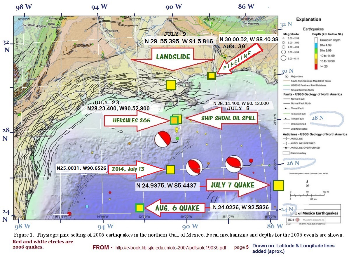
NOTE: The map is drawn on a map showing the 2006 Gulf of Mexico quake. This Lisaleaks post says the 2006 quakes were centered around a deep water drill site – “…2006 Feb 10 M5.2 event with the epicentre near to BP Atlantis deep water production facility. “
This post has links to more maps – Map Showing the 7-7 Quake, the Landslide and Ship Shoal oil leak
DATES (2013) and LOCATIONS:
- July 7 QUAKE – N 24.9375, W 85.4437
- July 9 LANDSLIDE – N 29. 55.395, W 91. 5.816
- July 8/9 SHIP SHOAL OIL RIG – N 28. 11.400, W 90. 12.000
- July 23 HERCULES 265 OIL RIG – N 28.23.400, W 90.52.800
- Aug. 5 Quake – N 24.0226, W92.5826
- Aug. 30 Gas Pipeline LEAK – N 30.00.52, W 88.40.38
All of these events are near the points affected by the Gulf of Mexico earthquake in 2006.
The NOAA Incident Map has a lot of items in the Gulf.
Video on the news blackout on this topic –
LINK – http://youtu.be/S2C28JiX7UY
USGS: Seismicity of the Earth 1900–2010 Mexico and Vicinity
2014
Oct. 3 – A new seafloor map of the world is released and we downloaded a map of the Gulf:

CLICK ON IMAGE FOR FULL SIZE
May 21 –LARGE 6.0 Quake in Gulf of Mexico – Near Texas
Check back here for updates.

Articles on Gulf of Mexico seismic events and the New Madrid Fault Zone

Mystery Earthquakes In Gulf Of Mexico

OLD
Info on the Gulf of Mexico and Faults

CLICK ON IMAGE FOR FULL SIZE
From – Honduras Quake is not near the Gulf of Mexico
Good fault maps: What if the big Plate at the Top of S. America Connected to Louisiana?

Reblogged this on On The Edge….
Just exploded AGAIN! It’s Youtube, I hate Youtube, give me a minute.
yeee-owwwwzaaa!
That’s some good information . Thanks .
On Wings of Care flyover video:
http://www.onwingsofcare.org/index.php/protection-a-preservation/gulf-of-mexico-oil-spill-2010/gulf-2013/418-20130723-hercules-rig-explosion-gom.html
You can see lots of big gas bubbles popping on the surface of the water, right underneath the plumes.
did you see recent explanation from officials (community meeting) that the gas bubbles are “raindrops” in size? Looks like a backed up toilet blowing in most spots!
no, i didn’t see that, but i did see bubbles waaay bigger than raindrops in the video.
they call ’em raindrops! Like a gas explosion being called a firecracker !!
Hope that works. This could be very very bad. It already is, but ya’ll know!
THANKS!!
heres something, I don’t know where to post it, please advise.
Tyler Tx sinkhole:
http://www.wafb.com/story/22915548/tyler-sinkhole-to-cause-delays
may be nothing but at this time who knows
where would it normally be posted?
here is OK!
Texas has a bunch of salr domes too …
Check out this article from Feb. 2013, really makes you think they have no idea what they’ve tapped into.
http://enenews.com/uncontrolled-gas-flow-continues-from-well-in-gulf-of-mexico-trying-to-stop-it-from-moving-underground
I was looking at same thing and wondered where 295 was in relation postings on map
Feb. 21, 2013 (Subscription Only): APACHE is seeking to kill a highly pressured gas well at Main Pass Block 295 in the Gulf of Mexico as jack-up rig Rowan Cecil Provine mobilises for possible relief drilling at the request of US regulators.
I put the location on a map to compare it ….
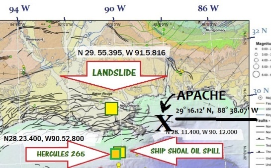
yikes!
Recently I added ‘Fuel Fix’ to the news section of the sidebar.
I think these things connect thru basement corridors….
Mary, Yes all these rigs seem to be about 50 or so miles out, which is kind of fishy to me.
“How a Jack-up Rig Blowout Occurs:
…While drilling, natural gas from the surrounding formation will quite frequently enter the wellbore as the rig crew is drilling down into the earth, and this pressurized flammable gas naturally wants to float to the surface.
So imagine a barrel-sized unit of natural gas enters the wellbore at 10,ooo feet below the rig.
According to Boyle’s Law, the volume of gas will double each time the pressure is halved. So at 5,000 feet, it’s expanded to 2 barrels, as it migrates up to 2,500 feet, it’s at 4 barrels, 1,250 feet – 8 barrels, and so on, until the bubble has expanded to the rig floor.
Left unmitigated, this kick can cause serious disaster on board a drilling rig, as witnessed in the case of the Hercules 265, and as seen in the Deepwater Horizon disaster.”
http://gcaptain.com/how-a-jackup-rig-blowout-occurs/
that’s a good one!
i found it helpfully “Explain It Like I’m 5” 😉
considerately jargon-free.
Thanks so much for map and updates. Really scarry when you think how many of these well are blowing up in such close proximity at such high pressure. Not to mention all the gas being released on land, sinkhole, etc. I wonder if any studies have been performed to see what the sea floor was and if it has risen…if so how much…just wondering. Tried to research but not luck.
The other explanation that would de-bunk the idea of big methane undersea leak or fissure from BP disaster site would be if these rigs are allowed to fail for some underhanded profit reason. Like maybe they are unproductive and somehow the operators get a big insurance pay off. Or if local refineries get to jack up prices based on less product, etc.
But that seems like a stretch.
But, even though it would be a dirty deal… it would be less scary than our idea about methane shoving up under the Gulf and inland in the bayous.
so once all the gas is gone from all these blowouts what replaces it Or not? like when you bake a cake and it rises and gets cracks in it and you stick a toothpick in it cause it still soft in the middle it sinks. I hope the whole gulf does not turn into a giant sinkhole…
I think it is like a gigantic flaring operation.
Welcome to Nigeria!
Pingback: The BP blow-out with a seafloor fissure sending methane below Bayou Corne scenario is true. They cannot stop the methane monster. (Repost) | Dublinmick's Breaking News
Reblogged this on orateague's Blog and commented:
2cracks in the road around the Lousiana sinkhole , more land simking ?