
LATEST MAP:
MANY FAULTS CONVERGE at Bright Bank Undersea Salt Dome in the Gulf of Mexico [has map]

Oct. 30, 2014

Oct. 7, 2014

July 13, 2014

CLICK ON MAP FOR FULL SIZE
July 2, 2014

May 21, 2014 –

CLICK IMAGE FOR FULL SIZE
LAST ‘ALL-QUAKES’ MAP:
This MAP will get updated as necessary.
[Dates with no year are 2013]
EARLIER MULTI-QUAKE MAP:
 CLICK ON IMAGE FOR FULL SIZE
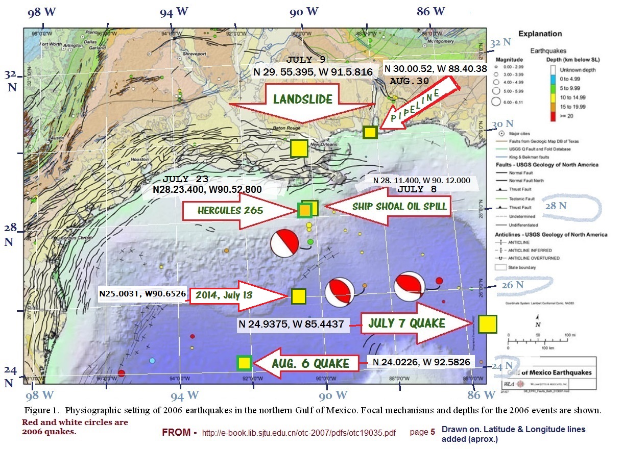
NOTE: The map is drawn on a map showing the 2006 Gulf of Mexico quake. This Lisaleaks post says the 2006 quakes were centered around a deep water drill site – “…2006 Feb 10 M5.2 event with the epicentre near to BP Atlantis deep water production facility. “
This post has links to more maps – Map Showing the 7-7 Quake, the Landslide and Ship Shoal oil leak
DATES (2013) and LOCATIONS:
- July 7 QUAKE – N 24.9375, W 85.4437
- July 9 LANDSLIDE – N 29. 55.395, W 91. 5.816
- July 8/9 SHIP SHOAL OIL RIG – N 28. 11.400, W 90. 12.000
- July 23 HERCULES 265 OIL RIG – N 28.23.400, W 90.52.800
- Aug. 5 Quake – N 24.0226, W92.5826
- Aug. 30 Gas Pipeline LEAK – N 30.00.52, W 88.40.38
All of these events are near the points affected by the Gulf of Mexico earthquake in 2006.
The NOAA Incident Map has a lot of items in the Gulf.
Video on the news blackout on this topic –
LINK – http://youtu.be/S2C28JiX7UY
USGS: Seismicity of the Earth 1900–2010 Mexico and Vicinity
2014
Oct. 3 – A new seafloor map of the world is released and we downloaded a map of the Gulf:

CLICK ON IMAGE FOR FULL SIZE
May 21 –LARGE 6.0 Quake in Gulf of Mexico – Near Texas
Check back here for updates.

Articles on Gulf of Mexico seismic events and the New Madrid Fault Zone

Mystery Earthquakes In Gulf Of Mexico

OLD
Info on the Gulf of Mexico and Faults

CLICK ON IMAGE FOR FULL SIZE
From – Honduras Quake is not near the Gulf of Mexico
Good fault maps: What if the big Plate at the Top of S. America Connected to Louisiana?
