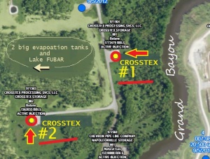
Butane cavern location on map – it is Crosstex Well #1 –
CLICK ON IMAGE FOR FULL SIZE
Above art from Louisiana DNR – Sept 2012
This flyover video clearly shows the location too.
This Face Book page has a great annotated PHOTO of it.
A lot of links on this post is in PDF format.
Louisiana DOTD map
art from http://www.edsuite.com/proposals/proposals_280/dotd_area_of_operations_fi_391.pdf
Where are the 2 Crosstex butane caverns?
The new location is called Well #1.
Crosstex plans to transfer butane Aug. 21:
BAYOU CORNE — Crosstex Energy LP of Dallas plans to begin on Tuesday shifting liquid butane from one underground storage cavern to another in the Napoleonville Salt Dome, moving the flammable product 1,000 feet farther away from a large sinkhole in northern Assumption Parish, company officials said. . . .
Crosstex has two caverns at its salt dome facility south of La. 70 South between Bayou Corne and Grand Bayou.
The cavern now holding the 940,000 barrels of liquid butane is 1,500 feet from the sinkhole.
The cavern Crosstex plans to move the butane into is 2,500 feet from the sinkhole, McMillan said.
Labeled “Well #1,” that cavern is filled with brine and empty of hydrocarbons, company officials told state regulators.
The cavern has a capacity of 1.7 million barrels and had held propane early this year, according to filings with the U.S. Securities and Exchange Commission.
Louisiana DEQ says not to worry, butane won’t blow up and why.
The upshot is they say because the butane is 1/2 mile below the surface and the sinkhole is only a few hundred feet deep they won’t intersect.
and Crosstex’s original letter to DEQ – http://www.slideshare.net/Revkin/louisiana-officials-little-risk-of-butane-explosion-at-sinkhole-site
Govenor’s Aug. 3 emergency order for Crostex to shut its pipeline near the sinkhole
Baton Rouge Today article ‘F.A.Q. ‘ goes into detail about the butane caverns (stored in and cavern it was moved to)
Copy of F.A.Q. article < Alt. link
From above:
Well #1 inspection report with a lot of data (aka: lease name, GUS J LABARRE #001):
http://www.edsuite.com/proposals/proposals_280/06292012_lease_facility_inspection_report_fi_293.pdf
Bubbling located 50 feet west of Well #1, serial no. 39252. (Photos bottom of page) dated June 29, 2012
Exact location of well – 30 0′ 9.2″ N, 91 8′ 41.9″ W
A 2009 FAILED Inspection Report. We put on our server so they can’t erase it. It was a bayou navigation hazard it says.
There’s a STREETVIEW option on this Bayou Corne Google Map. You get the STREETVIEW by clicking on the pin mark .
(This entry has been added to the MAP page on the sidebar)
shortlink to this page – http://wp.me/p2GNDM-fz


DEQ made me feel a whole lot better. Right. Crosstex did not present the worst case scenario.